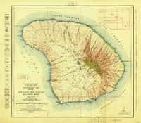
Island of Lanai, HI Historical Topo Map (1925)
by USGS Historical Topo Maps (public domain) · Hawaii, US
A free GeoPDF for offline GPS in the Cartahaven app, with free updates. How it works offline
Try it now, no account needed
Open this map in the Cartahaven map app in your browser and see your GPS position on it.
Older edition. This is the 1925 edition from the U.S. Geological Survey. A newer one may have been published since; check the agency's page for current rules and routes before relying on it.
About the Island of Lanai quad
The Island of Lanai quadrangle is a USGS 15-minute historical topo map covering about 19 × 17 mi of Maui County, Hawaii. This is the 1925 edition; the GeoPDF is 9.2 MB.
What you get
- Your GPS position on the map. A blue dot on this official sheet shows where you are.
- Works with no signal. Download it once; the map and your GPS position keep working with no cell signal.
- Tracks, placemarks and photos. Record where you go, drop pins, and export GPX, KML or GeoJSON.
- Free updates. When a new edition is published here, it’s yours at no cost.
- 1Tap “Get this map”: it’s added to your free account.
- 2Open the Cartahaven app on your phone and sign in.
- 3Tap “Get my maps”. It’s on your phone, ready offline.
The app runs on iPhone, Android and in desktop browsers. Install it · How offline GPS works
Where this map covers
Named places on this map
127 named features inside the Island of Lanai, HI — USGS historical 15-minute topo (1925) sheet, from the USGS Geographic Names Information System. Each one links to every map that shows it.
Peaks and ridges
- Haʻalelepaʻakai
- Hoopapalani Hill
- Hulupuuniu
- Iliolono
- Kaena
- Kahilikalani
- Kahinahina Ridge · ridge
- Kaʻaealiʻi
- Kaʻapahu
- Kākaʻalani
- Kamiki Ridge · ridge
- Kānepuʻu
- Kaonohiokala Ridge · ridge
- Kapukaloa
- Kauiki
- Kehewai Ridge · ridge
- Kuamoʻo Ridge · ridge
- Lānaʻihale
- Leinukalahua
- Mānele Cone
- Mauna o Umi
- Nīniniwai Hill
- Palea Ridge · ridge
- Pepeiaohuluhulu
and 21 more
Lakes, springs and falls
- Awahua Harbor · bay
- Hōnōpū Bay · bay
- Huawai Bay · bay
- Hulopoʻe Bay · bay
- Kaa Fishpond · reservoir
- Kaiolohia Bay · bay
- Kapihua Bay · bay
- Kaumalapau Harbor · bay
- Kaunolū Bay · bay
- Keone Bay · bay
- Kiʻei Bay · bay
- Kūahulua Bay · bay
- Loko Lōpā · reservoir
- Māmaki Bay · bay
- Mānele Bay · bay
- Sharks Bay · bay
- Waiʻōpae · reservoir
Gaps, arches and other landforms
- Anapuka · cape
- Anapuka · cape
- Hāʻua · cape
- Halealono · cape
- Halepalaoa Beach · beach
- Halulu · beach
- Hauola · cape
- Hiʻi Flats · flat
- Hinuhinu Pali · cliff
- Honowae · beach
- Honuaʻula Point · cape
- Hulopoʻe Beach · beach
- ʻĀwehi · cape
- Iamo · beach
- Kāheʻa · beach
- Kahemanō · beach
and 49 more
Elevations are the USGS 3DEP ground elevation at the named point, rounded; a summit's surveyed height can differ a little.
More maps of Hawaii.
Maps nearby
More maps around here ›
Lanai South, HI
Detailed map of terrain, trails and roads
USGS topo, 2024

Island of Lanai, HI
Old map for history, not navigation
USGS historical 15-minute topo (1923)

Lanai North, HI
Detailed map of terrain, trails and roads
USGS topo, 2024

Lanai South OE W, HI
Detailed map of terrain, trails and roads
USGS topo, 2024

Lanai North OE W, HI
Detailed map of terrain, trails and roads
USGS topo, 2024

Lanai South OE E, HI
Detailed map of terrain, trails and roads
USGS topo, 2024
Version history
Version 1 · Nov 6, 2026 · 9.2 MB